Grampians National Park is part of the Gariwerd Aboriginal cultural landscape. Parks Victoria respects the deep and continuing connection that Traditional Owners have to these lands and waters, and we recognise their ongoing role in caring for Country.
![]()
![]()
![]()
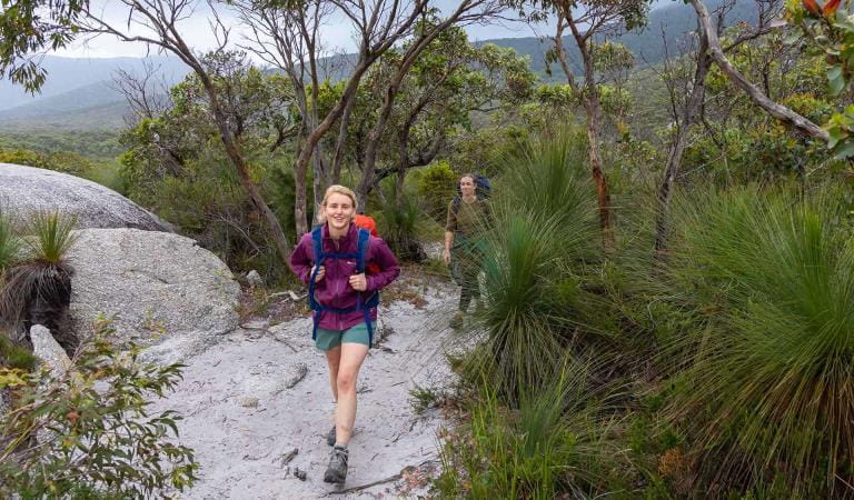
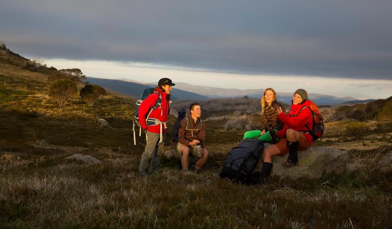
For people who enjoy an outdoor adventure but don’t have time to do the full 13-day Grampians Peaks Trail, breaking it up into smaller 3-day hikes is a great way to challenge yourself, build-up long distance hiking skills and experience the spectacular living cultural landscape of Gariwerd. Return again at your leisure to complete more sections of the trail.
You can also start with a suggested 3-day hike and add additional days of hiking using the GPT interactive map to create your preferred hiking adventure. Below are suggested 3-day hikes arranged in order from north to south.
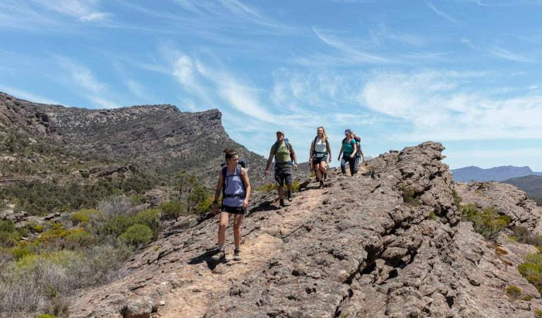
The Grampians Peaks trail is best completed in a north-to-south direction. This allows you to experience the most dramatic views on your hike as they reveal in the landscape. However, it can also be booked in south-to-north direction by using the GPT interactive map.
The Grampians Peaks Trail is free for anyone to walk on it, no charge. The 11 hike-in campgrounds have a fee, as do all bookable campgrounds in parks. These hike-in campgrounds are in very remote locations, you're not near a busy road or carpark, so you feel the reward of being deep inside the national park. They have been built with a good level of amenity that is well designed, sympathetic to the landscape and sustainable. As such, they are priced higher for the value they provide. The price for a tent pad for a 3-day/2-night hike is $100.80 ($50.40 p/person for two people sharing). That's roughly $50 per night ($25 p/person if sharing) in camping fees for these unique, well-equipped hike-in campgrounds. These fees contribute towards the operation and maintenance of this unique hiking experience and helps to protect the enviornmental values of this heritage-listed national park.
Water safety
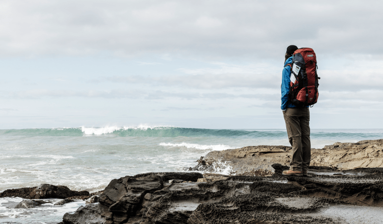
For your safety, having enough water along the Grampians Peaks Trail for hydration and cooking is so important. Our water information and availability page includes the locations (with latitude and longitude references) of serviced water tanks. All water tanks along the trail are untreated. So you need a safe way to treat water for drinking.
Plan and prepare
When planning this incredible hike, read the Grampians Peaks Trail Plan and Prepare Guide and order the official topographical maps from Brambuk the National Park and Cultural Centre in Halls Gap. And when the time comes, before you set-off, visit Brambuk and speak to knowledgeable staff for the latest park information.
Choose your preferred 3-day hiking itinerary
Gar and Werdug 3-day Hike

Bugiga and Barri Yalug 3-day Hike

Duwul and Durd Durd 3-day Hike

Yarram and Wannon 3-day Hike

Djardji-djawara and Mud-dadjug 3-day Hike
Grampians Peaks Trail Experiences
Grampians Peaks Trail

Day walks
Overnight Hikes

Full Grampians Peaks Trail (north to south)
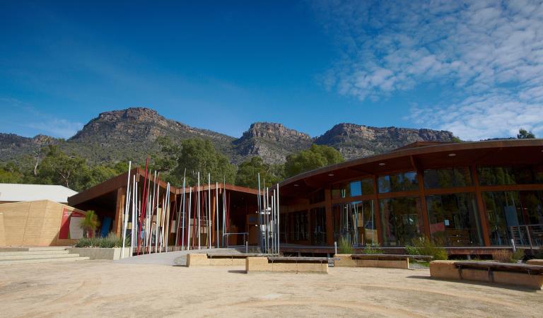
Brambuk The National Park and Cultural Centre
When you're there
Make Brambuk - The National Park and Cultural Centre in Halls Gap your first stop. Here you can explore what Gariwerd means to Aboriginal people and find information about visiting Grampians National Park.
Safety is your responsibility
- At lookouts, never climb over barriers. Your safety is more important than a social media post.
- There are steep cliffs in the park. Keep to the track, mind your footing and supervise children.
- Many walking tracks involve rock steps, uneven and slippery track surfaces, water crossings and rock hopping.
- Mobile phone service is unavailable in many areas of the park. Seek higher elevations for service.
- Plan your timing, return from walking well before dusk.
Emergency markers
In the event of an emergency, call Triple Zero 000 or 112 to access police and emergency services. Be aware that you may travel out of mobile phone range. Many of our parks feature emergency markers, which are special green signs with a unique code on them so emergency responders can pinpoint your exact location.
Need to know
3-day hikes
Walking track grades
Hikes along the Grampians Peaks Trail have been graded using the Australian walking track grading system, which is a primary means of informing people about the features of walking tracks, so they can gauge their suitability for a particular track. Under the system, walking trails are graded on a difficulty scale from grades one to five.
Grade 1: No bushwalking experience required. Flat even surface with no steps or steep sections. Suitable for assisted wheelchair users.
Grade 2: No bushwalking experience required. A hardened or compacted surface which may have gentle hill sections or occasional steps.
Grade 3: Suitable for most ages and fitness levels. Tracks may have short steep sections, a rough surface and many steps.
Grade 4: Bushwalking experience recommended. Tracks may be long, rough and very steep. Directional signage may be limited.
Grade 5: Very experienced bushwalkers with specialised skills, including navigation and emergency first aid. Tracks likely to be very rough, very steep and unmarked.
Be bushfire aware
The warmer months are the perfect time to experience regional Victoria. However, Victoria is one of the most fire-prone areas in the world. During summer in Victoria, the weather can be very hot and dry and the risk of summer lightning storms can increase the chance of bushfires.
Follow these bushfire safety tips to ensure that your experience is safe and enjoyable.
Change of Conditions
Nature being nature, sometimes conditions can change at short notice. It’s a good idea to check this page ahead of your visit for any updates.
-
Grampians National Park
Mt Zero Road Closure – Mud Hut Creek bridge replacement – 7th May to July 2024
Mt Zero Road will be closed between Roses Gap Road and north of Heatherlie Quarry between 7th May and July 2024 while the Department of Environment Energy and Climate Action (DEECA) undertakes critical bridge replacement works approximately 100m south of Roses Gap Road.Visitors wishing to travel between Halls Gap, Roses Gap and the Northern Grampians area (Hollow Mountain, Mt Zero and Mt Stapylton) will need to follow a detour via Ledcourt and Lake Lonsdale areas. See attached map.Plantation Campground and Heatherlie Quarry are still accessible from Mt Zero Road south (Halls Gap) or Pines Road.For further information on national park access please contact Brambuk the National Park and Cultural Centre phone 8427 2058Attachments: Mud Hut Creek - Bridge Works 2024 (584KB)
Grampians (Gariwerd) National Park - Bushfire Closures Update - April 26, 2024
Grampians (Gariwerd) National Park was impacted by the Bellfield and Stapylton bushfires from 13th February 2024. There are temporary closures still in place in the vicinity of the fires. Visitors are asked to adhere to road and park closures as we work to assess and re-open these areas.Northern Grampians (Mt Stapylton Fire) Closures remaining April 26, 2024:Road/track closures east of Mt Zero RoadGolton trackCrutes track/Crutes roadNo off-track walking within the burnt areaMt William Range (Bellfield Fire) - Closures remaining April 26, 2024Tunnel Walking TrackMt Cassell TrackPomonal FirelineBirdrock RdNo off-track walking within the burnt areaAll other areas of the Grampians (Gariwerd) National Park previously closed due to the fires have been re-opened.For further information about the closures, please visit Brambuk the National Park & Cultural Centre, or call (03) 8427 2258. For National Park Information visit www.parks.vic.gov.au, or for booking refunds email info@parks.vic.gov.auPlease visit www.emergency.vic.gov.au for emergency updates, or free call 1800 226 226. Monitor the Emergency Vic app for alerts and warnings or listen to your local ABC radio stations for emergency broadcasts.Mountain Lion (Designated rock-climbing and bouldering area) – Temporary exclusion
Mountain Lion (Designated rock-climbing and bouldering area) – Temporary exclusionSignificant Aboriginal cultural values have recently been rediscovered at the Mountain Lion designated rock-climbing and bouldering area.While Parks Victoria and Gariwerd Traditional Owners determine a longer-term management response, and out of respect for this significant cultural landscape, visitors are requested to not access this area.The Aboriginal Heritage Act 2006 protects Aboriginal cultural heritage and significant financial penalties apply for harm caused by individuals or corporate bodies.For more information please visit the FAQ Update at the Rock Climbing in Gariwerd link below.Grampians (Gariwerd) National Park - Roads Update 17.05.2024
The Grampians (Gariwerd) National Park has several roads temporarily closed for repair works, upgrades, and recent fire impacts. Please be aware the movement of visitors in these parts of the National Park is restricted
Planned Burn – Temporary Road ClosuresCassidy Gap Rd from Cassidy Gap GPT Trailhead to Sierra Fireline (MVO)Geerack TrackOslers Track between Red Gum Lease and Pines Rd
Road ClosuresMt Zero Rd (Pines Rd-Roses Gap Rd) is closed for bridge replacement works between Roses Gap Rd and north of Heatherlie Quarry from May 7 until the end of July 2024.
Mitchell Rd between Redman Rd and Mt William Picnic Ground Rd.
Seasonal Closures
Launders and Sanders Tracks are closed.Moora Moora Track is partially closed in the southern section, from Homestead Track intersection to Glenelg River Road.
Grampians Peaks Trail – Trailhead Access
Road access (Griffin Track) to the Griffin Trailhead for the Grampians Peaks Trail is open to 4WD vehicles only. Walkers can access the GPT on foot via the Griffin Track from the Grampians Tourist Road.
Please see the latest road report attachment for full road and track details at the bottom of this page.Attachments: Grampians (Gariwerd) National Park - Road Report - 17.05.2024 (280KB)
-
Notices Affecting Multiple Sites
Planned Burn Update – Cassidy Gap
FMVIC have now completed the following Planned Burn within Grampians (Gariwerd) National Park.Cassidy Gap (GR-WIM-CAV-00071)This burn is located 3km north of Dunkeld and includes section S3 of the Grampians Peaks Trail.The following visitor areas are now reopened, however, please adhere to “Don’t walk off the track” signage.· Grampians Peaks Trail (Section S3) north and south bound hiking between Cassidy Gap Rd Trailhead, over Signal Peak to Dunkeld Reservoir Road.· Mud-Dadjug Hike-in Campground.· Mt Abrupt carpark· Signal Peak walking trackThe following roads remain closed, please follow directions, and do not enter:· Serra Range Fireline is closed at the intersection of Vic Valley Road and Cassidy Gap Road· Cassidy Gap Road from closed from its intersection with Serra Range Fireline to its intersection with Grampians Rd.Visit & Sign Up: Sign up to Planned Burns Victoria www.vic.gov.au/plannedburns Set up automated notifications about upcoming planned burns on public land near you. There is no charge to sign up to receive text messages.Download: The Vic Emergency App. Set up a watch zone and choose to be notified about planned burns in the ‘alerts’ settingsCall: The Vic Emergency Hotline on 1800 226 226 and request an interpreter or assistance for hearing difficulties via the National Relay Service. IN AN EMERGENCY CALL 000Email: For specialist advice about planned burns in the Wimmera District you can contact Horsham FFMVic Office at wimmera.fuelmanagement@delwp.vic.gov.au or phone the office on (03) 8508 1222.For Information about park closures and campground bookings within Grampians (Gariwerd) National Park:Visit the Parks Victoria website: https://www.parks.vic.gov.au/places-to-see/parks/grampians-national-park#change-of-conditionsVisit: Brambuk the National Park and Cultural Centre – 277 Grampians Road Halls Gap, Ph 8427 2058 or for bookings and cancellations advice contact the Parks Victoria Information Centre Ph 13 1963 or email info@parks.vic.gov.auYou may see or smell smoke in the vicinity of the burn. For advice on how this may impact your health, visit www.epa.vic.gov.au/smokeGrampians National Park – Planned Burns Program
Forest Fire Management Victoria (FFMVic) have now completed the Autumn Planned Burns Program in Grampians (Gariwerd) National Park and surrounding reserves. Patrols and some road closure remain in place.Two additional planned burns have been scheduled for Winter (June/July 2024).These planned burns have been nominated and approved as part of the FFMVic three-year Joint Fuel Management Program for the Wimmera Fire District. Each burn has been designated to a year and season, though this may change depending on burn objectives and seasonal conditions. You can view the three-year plan at https://www.ffm.vic.gov.au/bushfire-fuel-and-risk-management/joint-fuel-management-programThe map attached, outlines the burns programmed for this year. Detailing the exact date and time of ignition can be difficult and the final decision to proceed may only be made on the day of the burn - once resources, weather conditions and local fuel moisture levels are deemed suitable. Once a burn is scheduled for ignition, FFMVIC will send out regular notifications.Some of the planned burns may involve the temporary closure of visitor sites, roads and campgrounds within Grampians Gariwerd National Park and other reserves. This may include detours or closures of hike in campgrounds along the Grampians Peaks Trail, and other vehicle-based campgrounds.· Closures will be enforced for the duration of ignition and may remain in place for some days. Visitor sites will re-open once the burn is declared safe.· We recommend that you seek information and stay informed about the status of the planned burns scheduled near you.Stay informed about FFMVic’s planned burns schedule:Visit & Sign Up:Sign up to Planned Burns Victoria to set up automated notifications about upcoming planned burns on public land near you. There is no charge to sign up to receive text messages.
Sign up via Planned Burns Victoria at www.vic.gov.au/plannedburnsDownload: the VicEmergency AppSet up a watch zone and choose to be notified about planned burns in the ‘alerts’ settingsCall: the VicEmergency Hotline on 1800 226 226 and request an interpreter or assistance for hearing difficulties via the National Relay ServiceEmail: For specialist advice about planned burns in the Wimmera District you can contact Horsham FFMVic Office at wimmera.fuelmanagement@delwp.vic.gov.au or phone the office on (03) 8508 1222.For Information about park closures and campground bookings within Grampians National Park:Visit the Parks Victoria website: https://www.parks.vic.gov.au/places-to-see/parks/grampians-national-park#change-of-conditionsVisit: Brambuk the National Park and Cultural Centre – 277 Grampians Road Halls Gap, Ph 8427 2058or for bookings and cancellations advice contact the Parks Victoria Information Centre Ph 13 1963 or email info@parks.vic.gov.auAttachments: Grampians Year 1 JFMP Map (17,972KB)
Planned Burn Update - Millstream Creek
FFMVic have completed the following planned burn.
Millstream Creek (GR-WIM-HGP-0081)This burn is located 6km west of Halls Gap.The following visitor areas have now reopened, however, please adhere to “Don’t walk off the track” signage.
· Boroka Lookout· Reeds Lookout· Lake Wartook Lookout· Lake Wartook· Mackenzie Falls precinct· Boroka Walking Track· Mackenzie River Walk (includes Fish Falls)· Smiths Mill CampgroundThe following roads have now reopened:· Old Mill Rd· Rose Creek Rd (north between Mt Victory Rd and Old Mill Rd)Visit & Sign Up: Sign up to Planned Burns Victoria www.vic.gov.au/plannedburns Set up automated notifications about upcoming planned burns on public land near you. There is no charge to sign up to receive text messages.Download: The Vic Emergency App. Set up a watch zone and choose to be notified about planned burns in the ‘alerts’ settings
Call: The Vic Emergency Hotline on 1800 226 226 and request an interpreter or assistance for hearing difficulties via the National Relay Service. IN AN EMERGENCY CALL 000Email: For specialist advice about planned burns in the Wimmera District you can contact Horsham FFMVic Office at wimmera.fuelmanagement@delwp.vic.gov.au or phone the office on (03) 8508 1222.For Information about park closures and campground bookings within Grampians (Gariwerd) National Park:Visit the Parks Victoria website: https://www.parks.vic.gov.au/places-to-see/parks/grampians-national-park#change-of-conditionsVisit: Brambuk the National Park and Cultural Centre – 277 Grampians Road Halls Gap, Ph 8427 2058 or for bookings and cancellations advice contact the Parks Victoria Information Centre Ph 13 1963 or email info@parks.vic.gov.auYou may see or smell smoke in the vicinity of the burn. For advice on how this may impact your health, visit www.epa.vic.gov.au/smokeGrampians (Gariwerd) National Park – Planned Burning Program
Forest Fire Management Victoria (FFMVic) have now completed the Autumn Planned Burns Program in Grampians (Gariwerd) National Park and surrounding reserves. Patrols and some road closure remain in place.Two additional planned burns have been scheduled for June/July 2024 (Winter).These planned burns have been nominated and approved as part of the FFMVic three-year Joint Fuel Management Program for the Wimmera Fire District. Each burn has been designated to a year and season, though this may change depending on burn objectives and seasonal conditions. You can view the three-year plan at https://www.ffm.vic.gov.au/bushfire-fuel-and-risk-management/joint-fuel-management-programThe map attached, outlines the burns programmed for this year. Detailing the exact date and time of ignition can be difficult and the final decision to proceed may only be made on the day of the burn - once resources, weather conditions and local fuel moisture levels are deemed suitable. Once a burn is scheduled for ignition, FFMVIC will send out regular notifications.Some of the planned burns may involve the temporary closure of visitor sites, roads and campgrounds within Grampians Gariwerd National Park and other reserves. This may include detours or closures of hike in campgrounds along the Grampians Peaks Trail, and other vehicle-based campgrounds.· Closures will be enforced for the duration of ignition and may remain in place for some days. Visitor sites will re-open once the burn is declared safe.· We recommend that you seek information and stay informed about the status of the planned burns scheduled near you.Stay informed about FFMVic’s planned burns schedule:Visit & Sign Up:Sign up to Planned Burns Victoria to set up automated notifications about upcoming planned burns on public land near you. There is no charge to sign up to receive text messages.
Sign up via Planned Burns Victoria at www.vic.gov.au/plannedburnsDownload: the VicEmergency AppSet up a watch zone and choose to be notified about planned burns in the ‘alerts’ settingsCall: the VicEmergency Hotline on 1800 226 226 and request an interpreter or assistance for hearing difficulties via the National Relay ServiceEmail: For specialist advice about planned burns in the Wimmera District you can contact Horsham FFMVic Office at wimmera.fuelmanagement@delwp.vic.gov.au or phone the office on (03) 8508 1222.For Information about park closures and campground bookings within Grampians National Park:Visit the Parks Victoria website: https://www.parks.vic.gov.au/places-to-see/parks/grampians-national-park#change-of-conditionsVisit: Brambuk the National Park and Cultural Centre – 277 Grampians Road Halls Gap, Ph 8427 2058or for bookings and cancellations advice contact the Parks Victoria Information Centre Ph 13 1963 or email info@parks.vic.gov.auAttachments: Grampians Year 1 JFMP Map (17,972KB)
Similar experiences at other parks
Hike for 1–3 nights
Great South West Walk
Wilderness Coast Walk
Falls to Hotham Alpine Crossing
Wilsons Promontory Northern Overnight Hikes