Mountain Lion (Designated
rock-climbing and bouldering area) – Temporary exclusion
Significant Aboriginal
cultural values have recently been rediscovered at the Mountain Lion designated
rock-climbing and bouldering area.
While Parks Victoria and
Gariwerd Traditional Owners determine a longer-term management response, and
out of respect for this significant cultural landscape, visitors are
requested to not access this area.
The Aboriginal Heritage
Act 2006 protects Aboriginal cultural heritage and significant financial
penalties apply for harm caused by individuals or corporate bodies.
For more information please
visit the FAQ Update at the Rock Climbing in Gariwerd link below.
Grampians
(Gariwerd) National Park was impacted by the Bellfield and Stapylton
bushfires from 13th February 2024. There are temporary
closures still in place in the vicinity of the fires. Visitors are
asked to adhere to road and park closures as we work to assess and re-open
these areas.
Northern Grampians (Mt Stapylton Fire) Closures remaining
April 26, 2024:
Road/track closures east of Mt Zero Road
Golton track
Crutes track/Crutes road
No off-track walking
within the burnt area
Mt William
Range (Bellfield Fire) - Closures remaining April 26, 2024
Tunnel Walking Track
Mt Cassell Track
Pomonal Fireline
Birdrock Rd
No off-track walking
within the burnt area
All other areas of the Grampians (Gariwerd) National
Park previously closed due to the fires have been re-opened.
For further information about the closures,
please visit Brambuk the National Park & Cultural Centre, or call (03) 8427
2258. For National Park Information visit www.parks.vic.gov.au, or for booking refunds email info@parks.vic.gov.au
Please visit www.emergency.vic.gov.au for emergency updates, or free call 1800 226 226. Monitor the
Emergency Vic app for alerts and warnings or listen to your local ABC radio
stations for emergency broadcasts.
Mt Zero Road will be
closed between Roses Gap Road and north of Heatherlie Quarry between the 7th of May
and July 2024 while the Department of Environment Energy and Climate Action
(DEECA) undertakes critical bridge replacement works approximately 100m south
of Roses Gap Road.
Visitors wishing to travel
between Halls Gap, Roses Gap and the Northern Grampians area (Hollow Mountain,
Mt Zero and Mt Stapylton) will need to follow a detour via Ledcourt and Lake
Lonsdale areas. See attached map.
Plantation Campground and
Heatherlie Quarry are still accessible from Mt Zero Road south (Halls Gap) or
Pines Road.
For further information on
national park access please contact Brambuk the National Park and Cultural
Centre phone 8427 2058
For bridge replacement
project information email roadsandcrossings@delwp.vic.gov.au
Attachments:
Mud Hut Creek - Bridge Works 2024 (584KB)
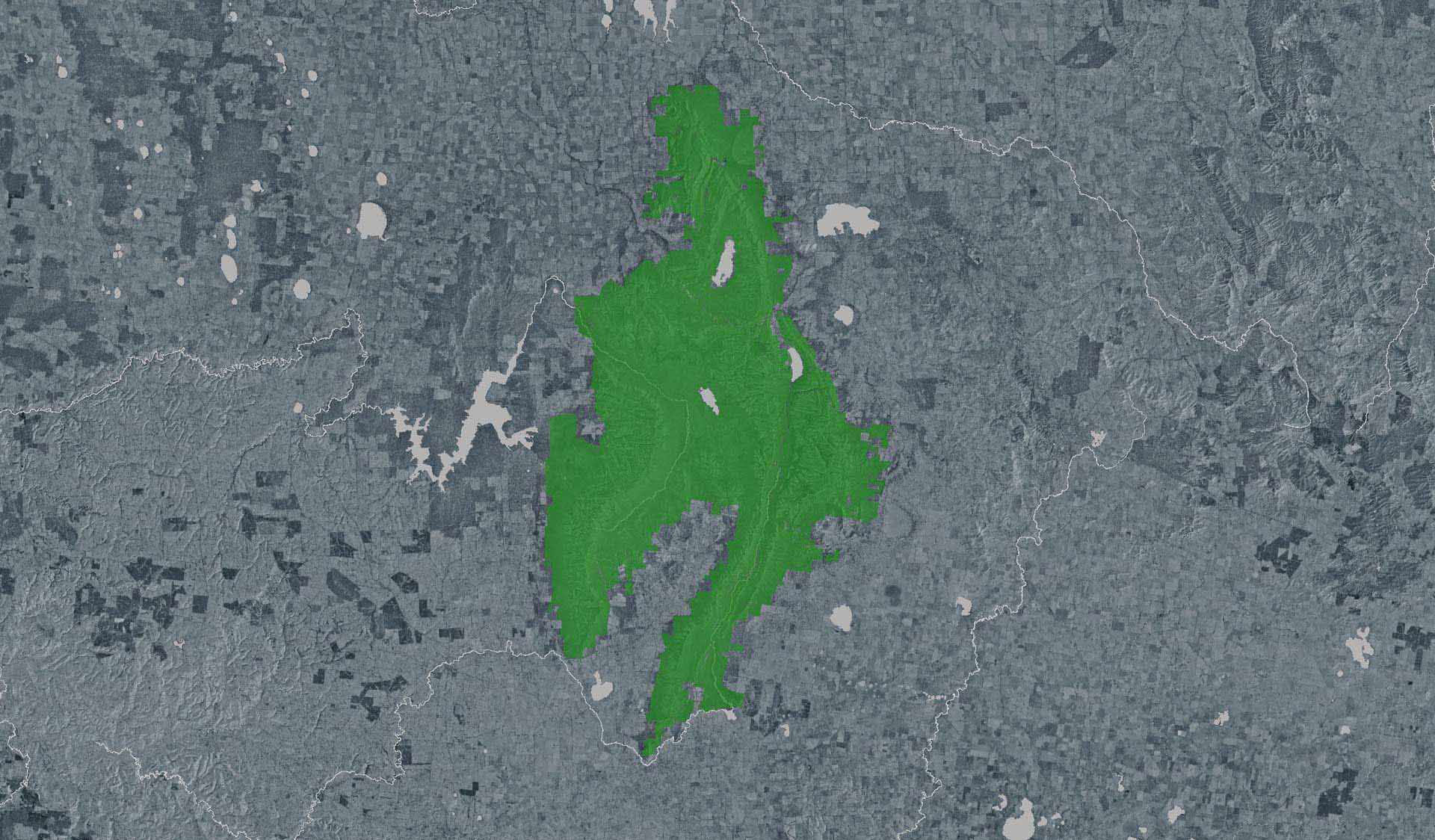
Grampians (Gariwerd) National Park – Autumn
Planned Program Underway
Forest Fire Management Victoria
(FFMVic) have commenced the Autumn Planned Burning Program in Grampians
(Gariwerd) National Park and surrounding reserves.
The
map attached, outlines the burns programmed for this year. Detailing the
exact date and time of ignition can be difficult and the final decision to
proceed may only be made on the day of the burn - once resources, weather
conditions and local fuel moisture levels are deemed suitable. Once a burn is
scheduled for ignition, FFMVIC will send out regular notifications.
Some
of the planned burns this Autumn may involve the temporary closure of visitor
sites, roads and campgrounds within Grampians Gariwerd National Park and other
reserves. This may include detours or closures of hike in campgrounds along
the Grampians Peaks Trail, and other vehicle-based campgrounds.
· Closures
will be enforced for the duration of ignition and may remain in place for some
days. Visitor sites will re-open once the burn is declared safe.
· We
recommend that you seek information and stay informed about the status of the
planned burns scheduled near you.
Stay informed about this Autumns
planned burns schedule:
Visit & Sign Up:
Sign up to Planned Burns Victoria to
set up automated notifications about upcoming planned burns on public land near
you. There is no charge to sign up to receive text messages.
Sign up via Planned Burns Victoria at www.vic.gov.au/plannedburns
Download: the VicEmergency
App
Set up a watch zone and choose to be
notified about planned burns in the ‘alerts’ settings
Call: the
VicEmergency Hotline on 1800 226 226 and request an interpreter or
assistance for hearing difficulties via the National Relay Service
For Information about park closures and
campground bookings within Grampians National Park:
Visit: Brambuk the National Park and
Cultural Centre – 277 Grampians Road Halls Gap, Ph 8427 2058
or for bookings and cancellations
advice contact the Parks Victoria Information Centre Ph 13 1963 or email info@parks.vic.gov.au