Rhyll Local Port Area Plan Project
Project status
December 2023
- Parks Victoria is developing a local port area plan for Rhyll, Phillip Island.
- Initial background research, technical investigations and stakeholder input is now complete.
- These inputs are being used to inform the draft plan, which will be released for wider community feedback in early 2024.

The project
This project is being delivered on Bunurong Sea Country.
A new plan is in development prioritising decisions on the future management of Rhyll Jetty and the adjoining waters managed by Parks Victoria. The Rhyll Local Port Area Plan (plan) draws from the current understanding of the site, as well as ideas and aspirations generated from community feedback.
Focusing on the on-water elements managed by Parks Victoria, the plan will set out improvements to meet community needs, balancing and enhancing existing uses and creating new, safer recreation and tourism opportunities shoring up the future for Rhyll Jetty.
This includes considering commercial and visitor berthing opportunities and gaps for services on offer, channel widths and berths for large commercial vessels, ensuring any proposed future changes to Rhyll Jetty or the swing moorings contribute to an overall improvement in access.
Community feedback on the aspirations and requirements for a successful maritime facility will be sought at key stages to help inform the planning process. Further details around how stakeholders and community can get involved will be provided as the project progresses.
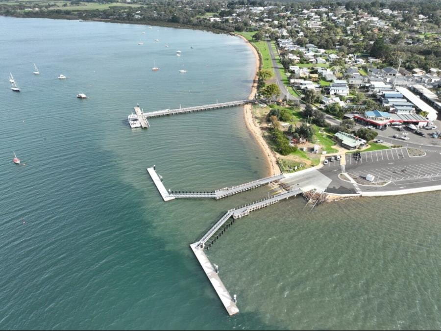
An aerial view of Rhyll local port area and supporting infrastructure (Credit: Better Boating Victoria)
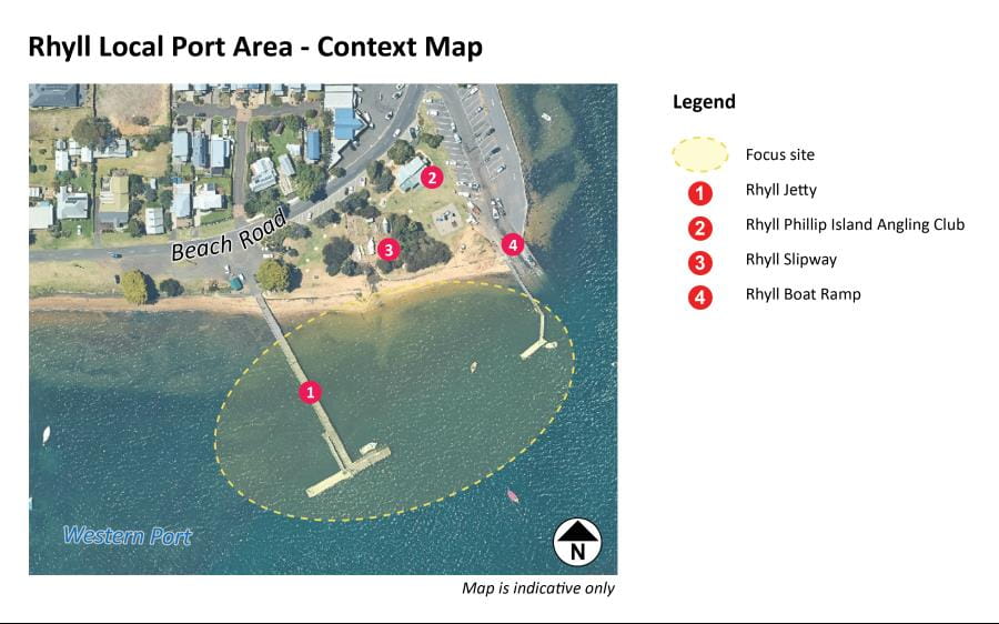
Map of the Rhyll Local Port Area Plan showing boundary of project focus site. Note: aerial map does not reflect recently upgraded boat ramp.
Background
Located on Phillip Island, Rhyll is popular with people accessing the many great recreational boating and fishing opportunities on offer in Western Port. Rhyll Jetty provides vital on-water access to popular Phillip Island tourism attractions, is an important destination for the cruise ship industry, and supports smaller local tour operators.
To ensure it continues to be a safe and thriving maritime asset for many more years to come, Parks Victoria is developing a plan for the jetty and adjoining water uses.
This project is part of the Victorian Government’s Sustainable Local Ports Framework and Parks Victoria's local ports forward planning program. Local ports play an important role for businesses and local communities. This plan will help guide Victorian Government investment priorities and provide a more sustainable approach to meeting economic, tourism and community needs.
Project funding
This planning project is funding by the Victorian Government via the Department of Transport and Planning.Who are we working with?
A project reference group comprising representatives from Parks Victoria, Bass Coast Shire Council, Destination Phillip Island, Department of Transport and Planning, and Bunurong Land Council Aboriginal Corporation will advise on the project.
Project timeline
- Background research and technical investigations – Spring 2023
- Preparation of the draft plan – Late Spring / Summer 2023
- Community consultation of draft plan – Early 2024
- Feedback considered – Early Autumn 2024
- Final plan released – Late Autumn - Mid 2024
Staying updated
For general enquiries email info@parks.vic.gov.au or call us on 13 1963.
Subscribe for project updates.
Related information
Parks Victoria is the local port manager for Port Phillip, Western Port and Port Campbell. The three local ports combined include 263,000 hectares of waterway, marine protected areas, channels, piers and jetties, moorings and aids to navigation.
Parks Victoria is currently undertaking a local port area planning process for Mornington, Sorrento, St Leonards and Williamstown and in Port Phillip. A final plan for Sandringham Harbour was released in late 2022.
Frequently asked questions
What is the Rhyll Local Port Area Plan project?
The Rhyll Local Port Area Plan project is about Parks Victoria engaging with stakeholders and the community to understand how they use the jetty, what challenges they experience and ideas for the future to help inform the development of a plan for the local port area. It will propose a future for Rhyll Jetty with consideration for safety, functionality, future demand and use, access and movement to serve users into the future as the community changes and grow.
Why is the plan needed?
There are many changing circumstances that have the potential to influence the future operation of the local port area, such as accommodating future demands for commercial and visitor berthing, the deteriorating condition of Rhyll Jetty, and sea level rise. The plan will also consider ways to make the jetty and surrounding waters safer and more accessible; and guide Victorian government on the priorities for the repair and renewal of infrastructure to meet future economic, tourism and community needs.
What does the project include?
The planning process will consider the following known challenges and other relevant matters that are raised throughout the process.
- Options for the future of Rhyll Jetty once it reaches the end of its design life
- Maritime safety and compliance with relevant standard for access channels
- A functional on-water layout which enhances activity, considers impacts on the swing moorings, and ensures that boat ramp functions are not impacted Opportunities for commercial berthing
- Opportunities for recreational uses and visitor berthing
What are the steps / processes involved in preparing the plan?
- Reviewing existing technical information and filling the gaps with new investigations where required.
- Consulting with key users and stakeholders to understand the challenges and aspirations for the jetty and water use.
- Preparing the draft plan and releasing it for community feedback.
- Amending the draft plan in response to what we’ve heard following consultation.
- Finalising the final plan for release.
How will stakeholders and key users be involved?
A project reference group has been established and includes representatives from State and local government, the peak tourism organisation, and the Traditional Owners. The planning process includes opportunities for stakeholders, key users and interest groups to provide input through meetings and emails to inform the development of the draft plan. Parks Victoria will contact these stakeholders directly.
How can community members contribute to project?
When a draft plan is developed, this will be made available for community input and comment. The consultation will be delivered on Engage Victoria and promoted locally to encourage input. To be kept informed about the project, register to receive updates or email the Project Team at engage@parks.vic.gov.au or call 13 1963.
Who is responsible for managing Rhyll Jetty?
Parks Victoria is responsible for the management of Rhyll Jetty and on-water infrastructure, as both the Port Manager for the local port of Western Port and as the Committee of Management for the Crown Land Reserve. Bass Coast Shire Council manages the foreshore, public boat ramp, and parking as Committee of Management.
When will the plan be implemented?
The plan sets out a future direction for each priority local port area and will be used to direct and prioritise future investment. Any changes proposed by the plan will need to be further developed and costed.
How will the heritage values of the precinct be considered in the future plan?
As part of the planning process, Parks Victoria will seek appropriately qualified consultants to provide advice on the heritage values of the Rhyll Jetty.
What is the current condition of Rhyll Jetty?
Rhyll Jetty was built more than 45 years ago and will reach the end of its design life in the coming years. The jetty has been closed to service vehicles since mid-2021. It was necessary to lower the load limit of the jetty to ensure safety, prevent further degradation and ensure it remains suitable for community use while its future and restored vehicle access is considered as part of the planning process. The jetty is open for pedestrian access and for use as a pickup/drop off berthing by commercial operators. Public vehicles have never been permitted to drive on the jetty.